PROJEKT HydroSAR
Sentinel-1-based InSAR analysis of groundwater variability for public management
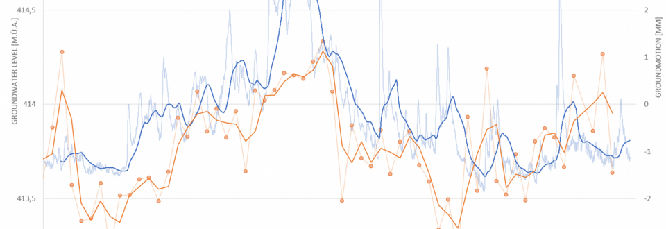
Copernicus satellites Sentinel-1A/B are capable of detecting millimetric surface change and are therefore excellently suited to assess the impacts of climate change. Currently, satellite-based radar interferometry (InSAR) is mainly used in research, implementation within the public administration has so far been limited. Satellite-based InSAR represents a prime instrument to identify groundwater-related land subsidence and uplift. As a result of climate change groundwater formation is expected to decrease over the upcoming years and decades while groundwater extraction is supposed to increase. Several studies have recently revealed significant seasonal shortages in groundwater supply throughout Europe. Potential future scarcity of vital groundwater will likely contribute to the emergence of regional conflicts over the utilization of groundwater which have to be managed and resolved by public authorities.
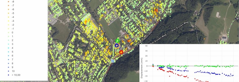
To prepare the public sector for the significant challenges related to climate change, HydroSAR aims at the implementation and long-term establishment of cutting-edge earth observation techniques (Sentinel-1) at the governmental level. To realize this overall aim Sentinel-1 data is used to measure groundwater-induced uplift/subsidence at millimeter accuracy in the province of Salzburg. Results will be compiled within an extensive database to assess present and future groundwater level changes. Based on the conducted InSAR analyses user-friendly digital maps will be created that will be made accessible to the public via the online GIS portal of the federal province of Salzburg (pilot application). In addition, a general guideline will be prepared that summarizes the implementation of HydroSAR and shall serve as a standard for future implementations of Sentinel-1 data in the public sector.
STECKBRIEF
Contribution GEORESEARCH: Lead
Project Partners: Geoconsult ZT GmbH, Technische Universität Graz, Land Salzburg, Salzburg AG
Project Duration: 2022 - 2024
Funding: FFG, ASAP18
Project Partner
TU Graz
Institute of Soil Mechanics, Foundation Engineering and Computational Geotechnics
Institute of Engineering Geodesy and Measurement Systems
Land Salzburg
Abteilung 6 - Infrastructure and Transport
Abteilung 7 - Water
SELECTED REFERENCES
Dörfler M. (2023): Potential von InSAR Daten für Gebäude- und Oberflächenmonitoring. Presentation at DigitalFindetStadt.
Hartmeyer I. (2023): Sinnvolle Entscheidungen in Zeiten des Klimawandels. Wissenschaftspodcast APA Science: Nerds mit Auftrag. https://nerds-mit-auftrag.podigee.io/31-hartmeyer.
Keuschnig M. (2023): Monitoring von Großhangbewegungen mit Salliten-basiertem InSAR und optischen Fererkundungsmethoden. Presentation at Geowissenschaftliches Kolloquium Universität Salzburg.
Valentin G. (2023): Flächendeckende Boden- und Bauwerksüberwachung mit Satelliten-basiertem InSAR. Presentation at Landesgeologentag 2023.
Dörfler M. (2023): Wide-area ground and structure monitoring with satellite-based InSAR. Presentation at Rockmechanics and Tunneling TU Graz.
Keuschnig M., Dörfler M., Hartmeyer I. (2023): Satellitenbasierte InSAR-Analyse von (klimawandelbedingten) Grundwasserschwankungen: Motivation & Ziele des FFG-Projekts "HydroSAR". Presentation at 23. Klimatag Leoben.
Keuschnig M., Dörfler M. (2023): Der präzise Blick aus dem Weltall: Flächendeckende Boden- und Bauwerksüberwachung mit Satelliten-basiertem InSAR. Keynote at Vermessungs- und GIS Experten aller Bundesländer Österreichs.


